|
| at: |
Talladega National Forest |
Data from USFS GIS
 show on map
 animate
Trail users:


Elevation Profile
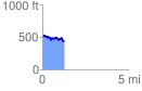
 1.297374 mi
 147.61 ft
 216.67 ft
 -69.06 ft
 3.16 %
GPX Downloads: Track Route
![]()
|
| at: |
Talladega National Forest |
show on map
animate
1.297374 mi
147.61 ft
216.67 ft
-69.06 ft
3.16 %