| at: |
Talladega National Forest |
Data from USFS GIS
 show on map
 animate
Trail users:


Elevation Profile
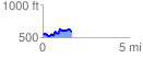
 1.678882 mi
 226.54 ft
 195.04 ft
 31.50 ft
 2.56 %
GPX Downloads: Track Route
![]()
| at: |
Talladega National Forest |
show on map
animate
1.678882 mi
226.54 ft
195.04 ft
31.50 ft
2.56 %