|
| at: |
Blue Ridge WMA Bull/Jake Mountain |
Data from David Muse
 show on map
 animate
Trail users:


Elevation Profile
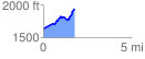
 1.759447 mi
 410.02 ft
 120.57 ft
 289.44 ft
 4.41 %
GPX Downloads: Track Route
![]()
|
| at: |
Blue Ridge WMA Bull/Jake Mountain |
show on map
animate
1.759447 mi
410.02 ft
120.57 ft
289.44 ft
4.41 %