|
| at: |
Talladega National Forest |
Data from USFS GIS
 show on map
 animate
Trail users:


Elevation Profile
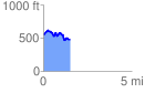
 1.525610 mi
 232.21 ft
 306.23 ft
 -74.03 ft
 3.80 %
GPX Downloads: Track Route
![]()
|
| at: |
Talladega National Forest |
show on map
animate
1.525610 mi
232.21 ft
306.23 ft
-74.03 ft
3.80 %