| at: |
Talladega National Forest |
Data from USFS GIS
 show on map
 animate
Trail users:


Elevation Profile
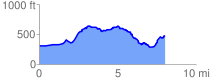
 8.209352 mi
 848.24 ft
 684.89 ft
 163.34 ft
 1.96 %
GPX Downloads: Track Route
![]()
| at: |
Talladega National Forest |
show on map
animate
8.209352 mi
848.24 ft
684.89 ft
163.34 ft
1.96 %