| at: |
Talladega National Forest |
Data from USFS GIS
 show on map
 animate
Trail users:


Elevation Profile
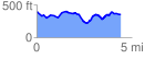
 4.447823 mi
 462.87 ft
 506.81 ft
 -43.95 ft
 2.16 %
GPX Downloads: Track Route
![]()
| at: |
Talladega National Forest |
show on map
animate
4.447823 mi
462.87 ft
506.81 ft
-43.95 ft
2.16 %