| at: |
Talladega National Forest |
Data from USFS GIS
 show on map
 animate
Trail users:


Elevation Profile
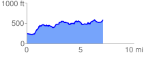
 7.165844 mi
 937.59 ft
 595.93 ft
 341.66 ft
 2.48 %
GPX Downloads: Track Route
![]()
| at: |
Talladega National Forest |
show on map
animate
7.165844 mi
937.59 ft
595.93 ft
341.66 ft
2.48 %