|
| at: |
Talladega National Forest |
Data from USFS GIS
 show on map
 animate
Trail users:


Elevation Profile
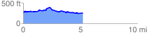
 5.239158 mi
 430.02 ft
 442.31 ft
 -12.29 ft
 1.60 %
GPX Downloads: Track Route
![]()
|
| at: |
Talladega National Forest |
show on map
animate
5.239158 mi
430.02 ft
442.31 ft
-12.29 ft
1.60 %