|
| at: |
Talladega National Forest |
Data from USFS GIS
 show on map
 animate
Trail users:


Elevation Profile
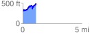
 1.136874 mi
 347.06 ft
 153.90 ft
 193.16 ft
 5.78 %
GPX Downloads: Track Route
![]()
|
| at: |
Talladega National Forest |
show on map
animate
1.136874 mi
347.06 ft
153.90 ft
193.16 ft
5.78 %