|
| at: |
Talladega National Forest |
Data from USFS GIS
 show on map
 animate
Trail users:


Elevation Profile
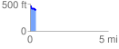
 0.372221 mi
 21.39 ft
 84.63 ft
 -63.23 ft
 4.31 %
GPX Downloads: Track Route
![]()
|
| at: |
Talladega National Forest |
show on map
animate
0.372221 mi
21.39 ft
84.63 ft
-63.23 ft
4.31 %