|
| at: |
Talladega National Forest |
Data from USFS GIS
 show on map
 animate
Trail users:


Elevation Profile
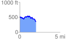
 2.015167 mi
 256.79 ft
 430.31 ft
 -173.52 ft
 4.04 %
GPX Downloads: Track Route
![]()
|
| at: |
Talladega National Forest |
show on map
animate
2.015167 mi
256.79 ft
430.31 ft
-173.52 ft
4.04 %