|
| at: |
Talladega National Forest |
Data from USFS GIS
 show on map
 animate
Trail users:


Elevation Profile
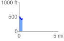
 0.449462 mi
 99.16 ft
 126.18 ft
 -27.02 ft
 5.32 %
GPX Downloads: Track Route
![]()
|
| at: |
Talladega National Forest |
show on map
animate
0.449462 mi
99.16 ft
126.18 ft
-27.02 ft
5.32 %