|
| at: |
Talladega National Forest |
Data from USFS GIS
 show on map
 animate
Trail users:


Elevation Profile
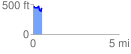
 0.505181 mi
 87.05 ft
 99.96 ft
 -12.90 ft
 3.75 %
GPX Downloads: Track Route
![]()
|
| at: |
Talladega National Forest |
show on map
animate
0.505181 mi
87.05 ft
99.96 ft
-12.90 ft
3.75 %