|
| at: |
Talladega National Forest |
Data from USFS GIS
 show on map
 animate
Trail users:


Elevation Profile
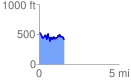
 1.574320 mi
 342.69 ft
 457.42 ft
 -114.73 ft
 5.50 %
GPX Downloads: Track Route
![]()
|
| at: |
Talladega National Forest |
show on map
animate
1.574320 mi
342.69 ft
457.42 ft
-114.73 ft
5.50 %