|
| at: |
Talladega National Forest |
Data from USFS GIS
 show on map
 animate
Trail users:


Elevation Profile
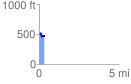
 0.338510 mi
 25.67 ft
 83.09 ft
 -57.41 ft
 4.65 %
GPX Downloads: Track Route
![]()
|
| at: |
Talladega National Forest |
show on map
animate
0.338510 mi
25.67 ft
83.09 ft
-57.41 ft
4.65 %