|
| at: |
Talladega National Forest |
Data from USFS GIS
 show on map
 animate
Trail users:


Elevation Profile
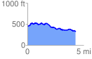
 4.396095 mi
 392.28 ft
 545.12 ft
 -152.84 ft
 2.35 %
GPX Downloads: Track Route
![]()
|
| at: |
Talladega National Forest |
show on map
animate
4.396095 mi
392.28 ft
545.12 ft
-152.84 ft
2.35 %