|
| at: |
Talladega National Forest |
Data from USFS GIS
 show on map
 animate
Trail users:


Elevation Profile
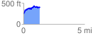
 1.345494 mi
 295.88 ft
 137.42 ft
 158.46 ft
 4.16 %
GPX Downloads: Track Route
![]()
|
| at: |
Talladega National Forest |
show on map
animate
1.345494 mi
295.88 ft
137.42 ft
158.46 ft
4.16 %