|
| at: |
Talladega National Forest |
Data from USFS GIS
 show on map
 animate
Trail users:


Elevation Profile
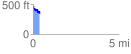
 0.399246 mi
 23.85 ft
 139.32 ft
 -115.47 ft
 6.61 %
GPX Downloads: Track Route
![]()
|
| at: |
Talladega National Forest |
show on map
animate
0.399246 mi
23.85 ft
139.32 ft
-115.47 ft
6.61 %