|
| at: |
Talladega National Forest |
Data from USFS GIS
 show on map
 animate
Trail users:


Elevation Profile
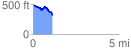
 1.120013 mi
 84.96 ft
 248.09 ft
 -163.13 ft
 4.20 %
GPX Downloads: Track Route
![]()
|
| at: |
Talladega National Forest |
show on map
animate
1.120013 mi
84.96 ft
248.09 ft
-163.13 ft
4.20 %