|
| at: |
Talladega National Forest |
Data from USFS GIS
 show on map
 animate
Trail users:


Elevation Profile
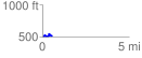
 0.560988 mi
 79.32 ft
 70.56 ft
 8.77 ft
 2.68 %
GPX Downloads: Track Route
![]()
|
| at: |
Talladega National Forest |
show on map
animate
0.560988 mi
79.32 ft
70.56 ft
8.77 ft
2.68 %