|
| at: |
Talladega National Forest |
Data from USFS GIS
 show on map
 animate
Trail users:


Elevation Profile
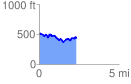
 2.341018 mi
 290.73 ft
 372.73 ft
 -81.99 ft
 3.02 %
GPX Downloads: Track Route
![]()
|
| at: |
Talladega National Forest |
show on map
animate
2.341018 mi
290.73 ft
372.73 ft
-81.99 ft
3.02 %