|
| at: |
Talladega National Forest |
Data from USFS GIS
 show on map
 animate
Trail users:


Elevation Profile
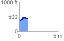
 1.120696 mi
 198.24 ft
 178.20 ft
 20.04 ft
 3.35 %
GPX Downloads: Track Route
![]()
|
| at: |
Talladega National Forest |
show on map
animate
1.120696 mi
198.24 ft
178.20 ft
20.04 ft
3.35 %