|
| at: |
Talladega National Forest |
Data from USFS GIS
 show on map
 animate
Trail users:


Elevation Profile
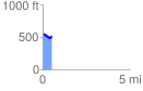
 0.525657 mi
 65.71 ft
 82.47 ft
 -16.77 ft
 2.97 %
GPX Downloads: Track Route
![]()
|
| at: |
Talladega National Forest |
show on map
animate
0.525657 mi
65.71 ft
82.47 ft
-16.77 ft
2.97 %