|
| at: |
Talladega National Forest |
Data from USFS GIS
 show on map
 animate
Trail users:


Elevation Profile
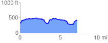
 7.209971 mi
 749.25 ft
 649.21 ft
 100.04 ft
 1.97 %
GPX Downloads: Track Route
![]()
|
| at: |
Talladega National Forest |
show on map
animate
7.209971 mi
749.25 ft
649.21 ft
100.04 ft
1.97 %