|
| at: |
Talladega National Forest |
Data from USFS GIS
 show on map
 animate
Trail users:


Elevation Profile
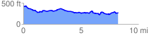
 8.351526 mi
 632.09 ft
 791.04 ft
 -158.96 ft
 1.79 %
GPX Downloads: Track Route
![]()
|
| at: |
Talladega National Forest |
show on map
animate
8.351526 mi
632.09 ft
791.04 ft
-158.96 ft
1.79 %