|
| at: |
Talladega National Forest |
Data from USFS GIS
 show on map
 animate
Trail users:


Elevation Profile
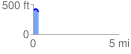
 0.348037 mi
 13.48 ft
 52.59 ft
 -39.11 ft
 2.86 %
GPX Downloads: Track Route
![]()
|
| at: |
Talladega National Forest |
show on map
animate
0.348037 mi
13.48 ft
52.59 ft
-39.11 ft
2.86 %