|
| at: |
Talladega National Forest |
Data from USFS GIS
 show on map
 animate
Trail users:


Elevation Profile
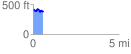
 0.594845 mi
 86.34 ft
 118.67 ft
 -32.33 ft
 3.78 %
GPX Downloads: Track Route
![]()
|
| at: |
Talladega National Forest |
show on map
animate
0.594845 mi
86.34 ft
118.67 ft
-32.33 ft
3.78 %