|
| at: |
Talladega National Forest |
Data from USFS GIS
 show on map
 animate
Trail users:


Elevation Profile
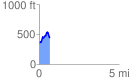
 0.667399 mi
 232.41 ft
 139.43 ft
 92.99 ft
 6.60 %
GPX Downloads: Track Route
![]()
|
| at: |
Talladega National Forest |
show on map
animate
0.667399 mi
232.41 ft
139.43 ft
92.99 ft
6.60 %