|
| at: |
Talladega National Forest |
Data from USFS GIS
 show on map
 animate
Trail users:


Elevation Profile
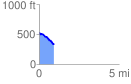
 0.939357 mi
 15.27 ft
 223.68 ft
 -208.41 ft
 4.51 %
GPX Downloads: Track Route
![]()
|
| at: |
Talladega National Forest |
show on map
animate
0.939357 mi
15.27 ft
223.68 ft
-208.41 ft
4.51 %