|
| at: |
Talladega National Forest |
Data from USFS GIS
 show on map
 animate
Trail users:


Elevation Profile
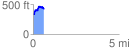
 0.619995 mi
 163.82 ft
 69.94 ft
 93.88 ft
 5.00 %
GPX Downloads: Track Route
![]()
|
| at: |
Talladega National Forest |
show on map
animate
0.619995 mi
163.82 ft
69.94 ft
93.88 ft
5.00 %