|
| at: |
Talladega National Forest |
Data from USFS GIS
 show on map
 animate
Trail users:


Elevation Profile
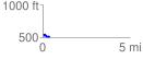
 0.393656 mi
 21.03 ft
 60.93 ft
 -39.90 ft
 2.93 %
GPX Downloads: Track Route
![]()
|
| at: |
Talladega National Forest |
show on map
animate
0.393656 mi
21.03 ft
60.93 ft
-39.90 ft
2.93 %