|
| at: |
Talladega National Forest |
Data from USFS GIS
 show on map
 animate
Trail users:


Elevation Profile
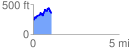
 1.057466 mi
 285.58 ft
 180.26 ft
 105.31 ft
 5.11 %
GPX Downloads: Track Route
![]()
|
| at: |
Talladega National Forest |
show on map
animate
1.057466 mi
285.58 ft
180.26 ft
105.31 ft
5.11 %