|
| at: |
Talladega National Forest |
Data from USFS GIS
 show on map
 animate
Trail users:


Elevation Profile
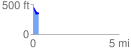
 0.331337 mi
 14.40 ft
 104.31 ft
 -89.91 ft
 5.96 %
GPX Downloads: Track Route
![]()
|
| at: |
Talladega National Forest |
show on map
animate
0.331337 mi
14.40 ft
104.31 ft
-89.91 ft
5.96 %