|
| at: |
Talladega National Forest |
Data from USFS GIS
 show on map
 animate
Trail users:


Elevation Profile
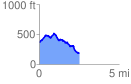
 2.558241 mi
 266.95 ft
 435.15 ft
 -168.19 ft
 3.22 %
GPX Downloads: Track Route
![]()
|
| at: |
Talladega National Forest |
show on map
animate
2.558241 mi
266.95 ft
435.15 ft
-168.19 ft
3.22 %