|
| at: |
Talladega National Forest |
Data from USFS GIS
 show on map
 animate
Trail users:


Elevation Profile
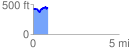
 0.855512 mi
 131.75 ft
 124.04 ft
 7.71 ft
 2.92 %
GPX Downloads: Track Route
![]()
|
| at: |
Talladega National Forest |
show on map
animate
0.855512 mi
131.75 ft
124.04 ft
7.71 ft
2.92 %