|
| at: |
Talladega National Forest |
Data from USFS GIS
 show on map
 animate
Trail users:


Elevation Profile
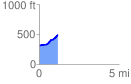
 1.194297 mi
 222.30 ft
 32.32 ft
 189.98 ft
 3.53 %
GPX Downloads: Track Route
![]()
|
| at: |
Talladega National Forest |
show on map
animate
1.194297 mi
222.30 ft
32.32 ft
189.98 ft
3.53 %