|
| at: |
Talladega National Forest |
Data from USFS GIS
 show on map
 animate
Trail users:


Elevation Profile
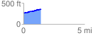
 1.444191 mi
 141.33 ft
 45.58 ft
 95.75 ft
 1.85 %
GPX Downloads: Track Route
![]()
|
| at: |
Talladega National Forest |
show on map
animate
1.444191 mi
141.33 ft
45.58 ft
95.75 ft
1.85 %