|
| at: |
Talladega National Forest |
Data from USFS GIS
 show on map
 animate
Trail users:


Elevation Profile
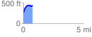
 0.798311 mi
 204.47 ft
 29.12 ft
 175.35 ft
 4.85 %
GPX Downloads: Track Route
![]()
|
| at: |
Talladega National Forest |
show on map
animate
0.798311 mi
204.47 ft
29.12 ft
175.35 ft
4.85 %