|
| at: |
Talladega National Forest |
Data from USFS GIS
 show on map
 animate
Trail users:


Elevation Profile
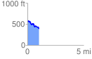
 1.009912 mi
 95.42 ft
 251.62 ft
 -156.20 ft
 4.72 %
GPX Downloads: Track Route
![]()
|
| at: |
Talladega National Forest |
show on map
animate
1.009912 mi
95.42 ft
251.62 ft
-156.20 ft
4.72 %