|
| at: |
Talladega National Forest |
Data from USFS GIS
 show on map
 animate
Trail users:


Elevation Profile
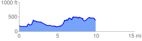
 10.085151 mi
 1134.13 ft
 1000.27 ft
 133.86 ft
 2.13 %
GPX Downloads: Track Route
![]()
|
| at: |
Talladega National Forest |
show on map
animate
10.085151 mi
1134.13 ft
1000.27 ft
133.86 ft
2.13 %