|
| at: |
Talladega National Forest |
Data from USFS GIS
 show on map
 animate
Trail users:


Elevation Profile
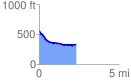
 2.325042 mi
 89.10 ft
 327.48 ft
 -238.38 ft
 2.67 %
GPX Downloads: Track Route
![]()
|
| at: |
Talladega National Forest |
show on map
animate
2.325042 mi
89.10 ft
327.48 ft
-238.38 ft
2.67 %