|
| at: |
Talladega National Forest |
Data from USFS GIS
 show on map
 animate
Trail users:


Elevation Profile
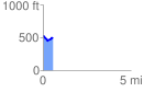
 0.566654 mi
 54.71 ft
 99.66 ft
 -44.95 ft
 3.33 %
GPX Downloads: Track Route
![]()
|
| at: |
Talladega National Forest |
show on map
animate
0.566654 mi
54.71 ft
99.66 ft
-44.95 ft
3.33 %