|
| at: |
Talladega National Forest |
Data from USFS GIS
 show on map
 animate
Trail users:


Elevation Profile
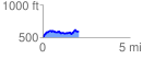
 2.072092 mi
 247.50 ft
 178.61 ft
 68.89 ft
 2.26 %
GPX Downloads: Track Route
![]()
|
| at: |
Talladega National Forest |
show on map
animate
2.072092 mi
247.50 ft
178.61 ft
68.89 ft
2.26 %