|
| at: |
Talladega National Forest |
Data from USFS GIS
 show on map
 animate
Trail users:


Elevation Profile
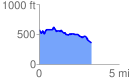
 3.316006 mi
 282.98 ft
 520.19 ft
 -237.21 ft
 2.97 %
GPX Downloads: Track Route
![]()
|
| at: |
Talladega National Forest |
show on map
animate
3.316006 mi
282.98 ft
520.19 ft
-237.21 ft
2.97 %