|
| at: |
Talladega National Forest |
Data from USFS GIS
 show on map
 animate
Trail users:


Elevation Profile
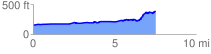
 7.610876 mi
 453.96 ft
 210.24 ft
 243.72 ft
 1.13 %
GPX Downloads: Track Route
![]()
|
| at: |
Talladega National Forest |
show on map
animate
7.610876 mi
453.96 ft
210.24 ft
243.72 ft
1.13 %