|
| at: |
Talladega National Forest |
Data from USFS GIS
 show on map
 animate
Trail users:


Elevation Profile
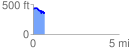
 0.683011 mi
 73.27 ft
 135.84 ft
 -62.57 ft
 3.77 %
GPX Downloads: Track Route
![]()
|
| at: |
Talladega National Forest |
show on map
animate
0.683011 mi
73.27 ft
135.84 ft
-62.57 ft
3.77 %