|
| at: |
Talladega National Forest |
Data from USFS GIS
 show on map
 animate
Trail users:


Elevation Profile
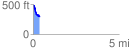
 0.366971 mi
 36.83 ft
 219.02 ft
 -182.19 ft
 11.30 %
GPX Downloads: Track Route
![]()
|
| at: |
Talladega National Forest |
show on map
animate
0.366971 mi
36.83 ft
219.02 ft
-182.19 ft
11.30 %