|
| at: |
Talladega National Forest |
Data from USFS GIS
 show on map
 animate
Trail users:


Elevation Profile
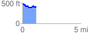
 1.160062 mi
 123.20 ft
 166.98 ft
 -43.78 ft
 2.73 %
GPX Downloads: Track Route
![]()
|
| at: |
Talladega National Forest |
show on map
animate
1.160062 mi
123.20 ft
166.98 ft
-43.78 ft
2.73 %