|
| at: |
Talladega National Forest |
Data from USFS GIS
 show on map
 animate
Trail users:


Elevation Profile
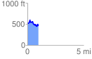
 0.970721 mi
 166.42 ft
 253.95 ft
 -87.53 ft
 4.95 %
GPX Downloads: Track Route
![]()
|
| at: |
Talladega National Forest |
show on map
animate
0.970721 mi
166.42 ft
253.95 ft
-87.53 ft
4.95 %