|
| at: |
Talladega National Forest |
Data from USFS GIS
 show on map
 animate
Trail users:


Elevation Profile
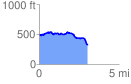
 3.052819 mi
 224.54 ft
 422.35 ft
 -197.81 ft
 2.62 %
GPX Downloads: Track Route
![]()
|
| at: |
Talladega National Forest |
show on map
animate
3.052819 mi
224.54 ft
422.35 ft
-197.81 ft
2.62 %